route-highlight
Past Two Weeks
route-highlight
route-highlight
route-highlight
route-highlight
route-highlight
+ 19

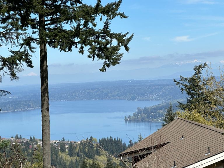
Cougar Mountain Climb and May Valley Loop

Cycling Route

Details
39.16 km
586 m
This “sufferfest” in the eastside Seattle suburbs takes you to a high overlook on
Cougar Mountain that at one time served as an anti-aircraft gun emplacement
and a missile base. Otherwise, it’s a flat ride along valley roads with a stop in the
historic mining and lumber village of Issaquah.

Things to see: Lake Boren; horses, llamas, and Highland cattle in pastures on May Valley Road; Issaquah fish hatchery and historic depot museum; Anti-Aircraft Peak at Cougar Mountain Park; coal-mining artifacts.

400m climb up to Cougar Mountain.
Created By
loneoceans g

Route and Elevation

Segments

NameDistanceElev. Diff.Avg. Grade
Olympus to SE 89th0.43 km-8 m-1.6%
May Valley TT - Eastbound - Total11.86 km-46 m-0.3%
May Valley TT Part 15.45 km11 m0.1%
SE May Valley Rd., Coal Creek to SE May Valley Rd. Junction3.46 km10 m0.1%
May Valley TT Part 25.93 km-46 m-0.5%
The Quah ITT 4.98 km-38 m-0.8%
JW - May Valley Rd to Iss3.71 km-29 m-0.8%
Iss-Hobart Rd. from May Valley to Newport Way5.06 km-37 m-0.7%
Chirico Trail Climb0.51 km7 m1.4%
th Avenue Northwest Climb0.46 km-6 m-0.4%
th Avenue Northwest Climb0.60 km-6 m-0.3%
Zoo hill from Newport Way4.20 km322 m7.7%
Bottom of Zoo to 174th Ave SE3.41 km286 m8.4%
Zoo Road up Cougar Mountain4.27 km380 m8.9%
Cougar- Unbroken Surge Up the Hill5.85 km404 m6.9%
Zoo Hill True Summit...except when the yuppies lock the gate!4.42 km380 m8.6%
Zoo Hill Climb3.56 km303 m8.5%
Cougar Explosion1.40 km162 m11.6%
Cougar Complete4.26 km383 m9.0%
Zoo Hill to Bus stop3.59 km297 m8.3%
Total Cougar Mountain Climb5.53 km397 m7.2%
Zoo Hill to Cougar Proper (Newport to USGS marker)5.76 km403 m7.0%
cougar mt. climb4.46 km373 m8.4%
Cougar Bottom - wink wink1.75 km180 m10.2%
Zoo hill with SE Cougar Mnt. Drive (3 miles)4.71 km374 m7.9%
Cougar complete climb: zoo to picnic table at summit5.72 km406 m7.1%
Cougar Mountain TT (official course)3.57 km294 m8.2%
Lower Zoo Climb1.38 km68 m4.9%
Cougar Mt starting from zoo3.42 km266 m7.7%
Cougar Top - nudge nudge1.84 km132 m7.2%
Top of Zoo climb from Monteux1.08 km84 m7.6%
Cougar Top to Rollover0.65 km67 m10.2%
Couger Mountain Dr. to the radio towers1.85 km83 m4.5%
Cougar Mountain Tip0.56 km59 m10.5%
Cougar Mountain gravel climb0.77 km37 m2.8%
Cougar Mountain summit to 60th1.75 km-83 m-4.7%
Cougar Way down: 168th to Lakemont1.25 km-91 m-7.2%
Par 5 Plays Fast4.07 km-98 m-2.4%
Newcastle WB flyer2.53 km-71 m-2.5%
Newcastle Time Warp0.45 km-27 m-5.9%