route-highlight
route-highlight
route-highlight
route-highlight
route-highlight
route-highlight
+ 176

Hazard's 5 Hour Legendary Gibralter Hill Climb Tour

Cycling Route

Details
56.18 km
1,611 m
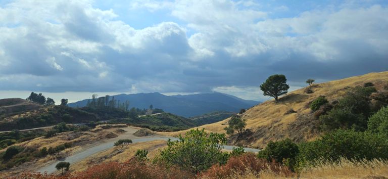
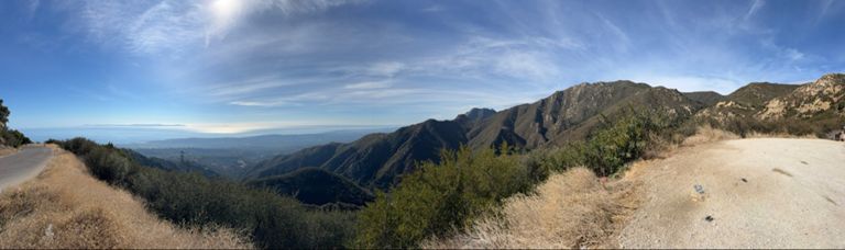
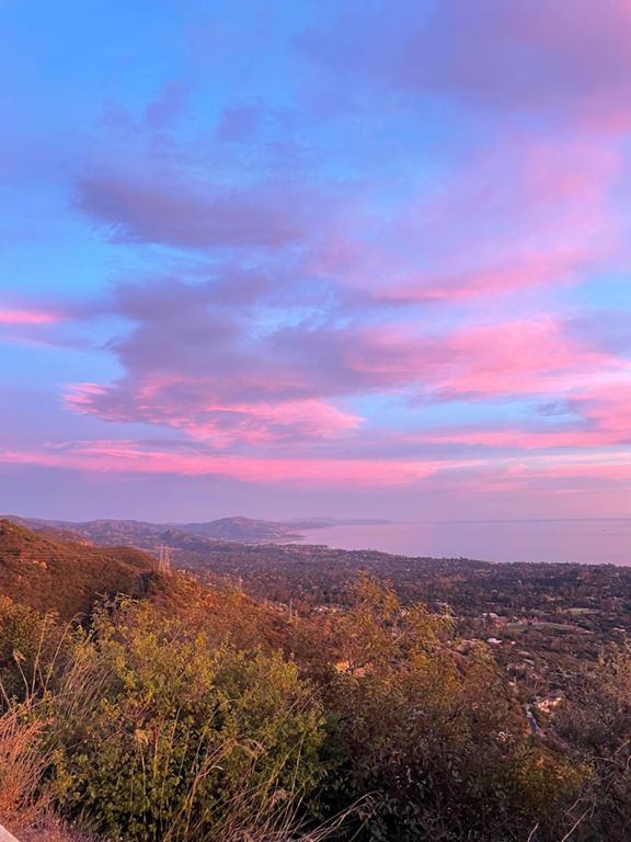
This guided ride starts with a short jaunt to the historical Santa Barbara Mission and then continues to the legendary Gibralter Hill Climb. The Gibralter Hill Climb has been featured in the most exciting stages of the Amgen Tour of California and has been ridden by some of the world's most famous cyclists from the likes of Peter Sagan to Phil Gaimon. It has even been featured on Phil Gaimon's YouTube series "Worst Retirement Ever". With our guided tour you get to experience even more than the pro tour riders and go all the way to top of the mountain where you will be in awe of the stunning views of Channel Island's national park and the Santa Ynez Valley. Once at the top, you ride across the ridge and finish your ride down some of the most exciting mountain road descents you will find anywhere in the world.

Fair warning, this ride is for intermediate to advanced riders but if you are feeling ambitious our guides will make sure you accomplish your ride and have one of the most amazing memories of your life to take home!
Created By
Peter B

Route and Elevation

Segments

NameDistanceElev. Diff.Avg. Grade
E Los Olivos St. to W Mountain Dr.0.38 km14 m1.6%
Mission to Mountain Dr. 2.35 km140 m6.0%
Mission to No Shooting7.25 km488 m6.7%
Mission Canyon Hill: Short: To Tremonto Rd.0.85 km55 m6.5%
Sheffler's Bane0.39 km27 m6.5%
RYBT Gibraltar Challenge6.75 km498 m7.3%
Base of Gibraltar to Climbing Rock7.61 km558 m7.3%
Gibraltar, Mountain to El Cielito0.57 km37 m5.8%
Gibraltar- bottom to u made it 20.75 km931 m3.9%
Gibraltar Climb9.92 km778 m8.2%
Gibraltar, Falling Rock Sign to Concrete Barriers2.48 km185 m7.4%
Gibraltar, Rock Sign to Mt Calvary1.07 km94 m8.8%
Gib (rock slide sign) to No Shooting (change of pavement, low side)4.18 km297 m7.1%
Share the Road sign to Mt Calvary0.46 km42 m8.4%
Gibraltar, Mt Calvary to Oak Tree3.65 km231 m6.3%
Gibraltar, Sprint to Concrete Barriers0.43 km29 m6.6%
Gibraltar, Upper Mid-section1.39 km112 m8.1%
No Shooting to top of Gibraltar5.77 km462 m8.0%
No Shooting to Flores Flats3.54 km258 m7.3%
Sprint to Flores Flat0.35 km24 m6.7%
Flores Flat -> Rattlesnake Park0.96 km108 m11.2%
Flores Flat to ECC2.13 km207 m9.7%
LaCumbreApproach2PaintedCave14.09 km-326 m-1.4%
Gibraltar TT - La Cumbre Peak last climb 1.89 km146 m7.7%
The real peak0.32 km14 m4.1%
CC downhill to glass factory4.34 km-256 m-5.9%
Arroyo Burro to San Marcos VOR2.14 km138 m6.4%
East Camino Cielo (Westbound)1.41 km88 m5.4%
E. camino to p cave dh4.35 km-213 m-4.9%
"the" Descent14.52 km-1,006 m-6.9%
Painted Cave Descent3.74 km-356 m-9.5%
Painted Cave Turns1.21 km-124 m-10.2%
OSM Descent4.63 km-358 m-7.7%
OSM Switchbacks Descent0.48 km-58 m-11.9%
Pedal to the Metal1.67 km-117 m-7.0%
Final Decent Sprint0.93 km-40 m-4.2%
Tuckers Sprint0.54 km6 m1.1%
3 Hills3.82 km52 m1.4%
Tuckers Grove to El Sueno1.94 km33 m1.0%
Turnpike Hill0.78 km33 m4.2%
192 Humps East: Turnpike to Mission Cyn7.52 km67 m0.9%
Dash to the Pass0.98 km-17 m-0.2%
Fireman's Hill - Backside0.26 km9 m3.2%
192 (La Cumbre Hill)0.60 km33 m5.5%
192 La Cumbre Hill - Full0.81 km49 m6.0%
To the bridge!0.90 km22 m2.2%
Gutterball0.39 km18 m4.5%
Mission Canyon Fun Downhill1.11 km-35 m-3.2%
You hop, iHop0.40 km-7 m-1.6%
Safety Sprint0.25 km-2 m-0.9%