route-highlight
route-highlight
route-highlight
route-highlight
route-highlight
route-highlight
+ 24

Daylesford with the National Champions

自行車路線

詳細資訊
120.76 公里
1,716 公尺
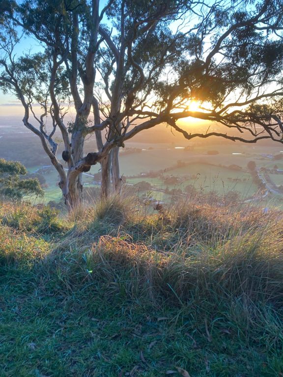
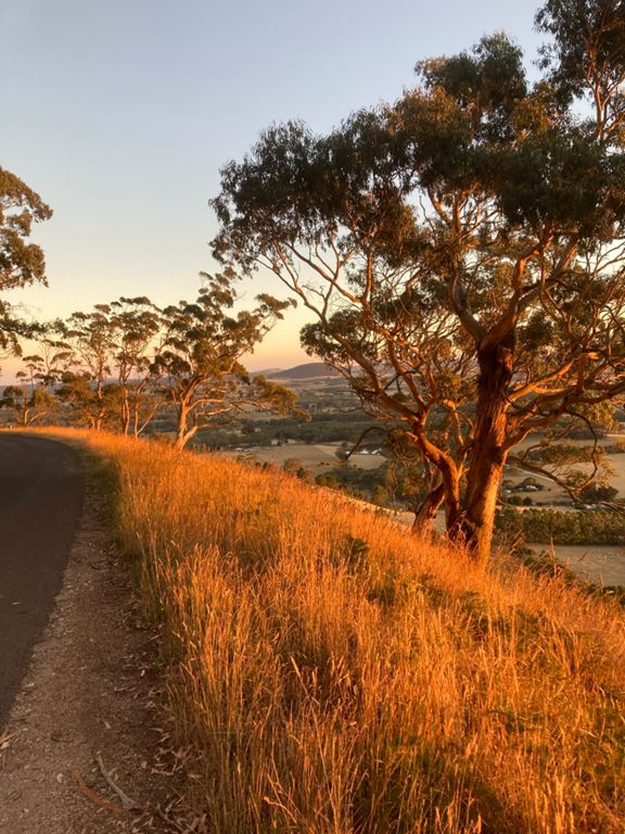
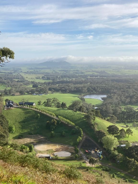
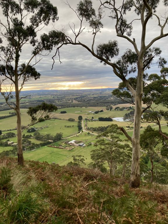
If you are after a challenge and in for the long haul.... This is the loop for you! Start at The Golden City Hotel and fuel up, trust me you are going to need it. You'll be heading off to Buninyong to ride the famous Australian Road Nationals Cycling course- With a Twist! We are taking you over the toughest part of the course, crest over the KOM when the winning move is always made, but you wont be turning left and staying on course. The legs will burn even more as you continue to head all the way up to the Buninyong lookout where you will get the best seat on the house to the views of Ballarat. Once you've caught your breath we will be hitting quite country roads, huge wind turbines and rolling hills and before you know it you'll be in the heart of the Wombat State Forrest. You'll feel as though you could be riding anywhere in the world and be taken by the beautiful scenery . Not log to go and and Daylesford will be on the horizon, time to stop, refuel and put the feet up before a brutal last final hour. A fun descent out of Daylesford before heading straight back up again- You'll take a left and enjoy more quite farm roads before... You guessed it! More climbing. You'll tackle Mollinghip hill before heading back over the local favourite white swan and water tower climbs. If you can get yourself up over them you are home and hosed! Straight through town and into Fika for their famous Blueberry and white chocolate muffins and the best coffee in town!
建立者:
Visit Ballarat

路線和海拔

路段

名稱距離海拔差異平均坡度
Grant St Climb East0.62 公里25 公尺4.0%
Sov hill to tinworth1.77 公里19 公尺1.0%
Geelong Rd - outbound6.59 公里80 公尺1.2%
Canadian Lakes to Midvale (Roundabouts)1.54 公里12 公尺0.5%
Midvale to Damascus0.92 公里21 公尺2.1%
Midvale to University Drive2.57 公里31 公尺1.2%
Damascus to Greenhill0.80 公里-8 公尺-0.9%
National Master Downhill Finish1.96 公里-58 公尺-2.9%
Mt Helen / Buninyong Decent1.72 公里-58 公尺-3.3%
downhill #roadnats sprint finish1.77 公里-53 公尺-2.9%
Buninyong the Final 700.0.68 公里-11 公尺-1.5%
Buninyong A300 Climb1.51 公里83 公尺5.5%
Its UP the hill we go0.90 公里42 公尺4.3%
Buninyong to Nationals KOM2.85 公里150 公尺5.3%
Buninyong to Mt Buninyong5.76 公里298 公尺5.2%
Buninyong Mid Climb1.33 公里83 公尺6.2%
West vic hill attacks!!0.41 公里23 公尺5.5%
Steep bit of the A300.0.56 公里41 公尺7.4%
Buninyong Nationals KoM1.07 公里65 公尺6.1%
Actual National KOM - Start sign to finish sign.0.98 公里70 公尺7.1%
Mount Buninyong - the top half2.66 公里149 公尺5.6%
the buni bit that hurts1.57 公里101 公尺6.4%
Up & down the summit5.46 公里149 公尺0.1%
Mt.B Road Pinch0.21 公里26 公尺12.2%
Mt Buninyong crossover to summit1.71 公里67 公尺3.9%
The final km KOM1.02 公里38 公尺3.7%
bunningyong descent2.46 公里-127 公尺-5.1%
Yendon No1 Road4.18 公里-84 公尺-2.0%
Tracks and Over - TT1.46 公里24 公尺1.3%
3km interval2.82 公里41 公尺1.3%
Egerton Rd Corkscrew0.44 公里22 公尺4.9%
Spargo Creek Rd7.24 公里58 公尺0.1%
Blampied ex Daylesford9.50 公里121 公尺0.1%
Bells Reef Rd Climb1.75 公里94 公尺5.3%
Powells Rd incline1.87 公里15 公尺0.8%
Madderns Descent1.74 公里-58 公尺-3.2%
Madderns Road from East1.35 公里-17 公尺-1.2%
White Swan Song3.02 公里-68 公尺-2.0%
Spring Road Decent0.86 公里-32 公尺-3.5%
Water Towers from Springs Rd4.60 公里81 公尺0.8%
White Swan Climb - East1.39 公里70 公尺5.0%
Hit the gas now punks!!!!0.71 公里31 公尺4.4%
White Swan - West Side Downhill fun1.97 公里-80 公尺-4.0%
Alkera Rd Climb North0.94 公里54 公尺5.7%
Watertowers descent - southbound0.57 公里-32 公尺-5.7%
Norman St. Peak 0.15 公里8 公尺5.5%
Norman St. Downhill Sprint1.36 公里-50 公尺-3.1%
Doveton St - Norman to Howitt sprint0.70 公里-15 公尺-2.0%
Norman to Crewick Road Dash2.30 公里-29 公尺-1.0%
Race to the PUB0.87 公里-8 公尺-0.8%