


+ 152
Ferndell Trail to the Mount Hollywood Summit
トレイルランニングルート
適度
5.3 mi
1,105 ft
A beautiful but non-technical run to the summit of Mount Hollywood.
The flanks of Mount Hollywood are riddled with trails and old road grades, providing innumerable options for reaching the summit. The route shown here is one of the easiest and most direct paths to the top of the mountain.
This route begins on the Ferndell Trail, itself an out-of-the-ordinary trail in the Los Angeles area. Ferndell "[borders] a stream that nourishes tropical plants under the shade of sycamores," according to [HikesPeak.com](https://www.hikespeak.com/trails/ferndell-trail-griffith-park-western-canyon/). "Even when other parts of Griffith Park dry out and turn brown, Ferndell stays lush and green, thanks to the recycled water it receives from Griffith Observatory," they continue.
While Ferndell is over quickly, this provides a fantastic start and end to this beautiful run! From the end of Ferndell, you'll begin climbing in earnest on the W Trail—a wide road grade that's smooth and provides easy running, even if it does climb consistently up the mountainside. Singletrack options do exist to bypass the road grade, but this route follows the road to maintain an "Easy" FATMAP difficulty rating.
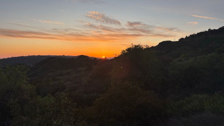
Higher up, you'll reach the named Mount Hollywood trail—again, another old dirt road. At the top, the route shown here includes a small loop for variety, or you can simply run an out-and-back. Once on top of the mountain, you'll enjoy spectacular views of Hollywood directly below you, Los Angeles beyond that, Santa Monica and the Pacific Ocean, and the San Gabriel mountains.
Once finished on the summit, the easiest option is to retrace your steps back to your car. However, as noted above, many other trails run up and down the mountainside, allowing you to create a loop if you so desire.
Sources:
https://www.hikespeak.com/trails/ferndell-trail-griffith-park-western-canyon/ Written by Greg Heil
The flanks of Mount Hollywood are riddled with trails and old road grades, providing innumerable options for reaching the summit. The route shown here is one of the easiest and most direct paths to the top of the mountain.
This route begins on the Ferndell Trail, itself an out-of-the-ordinary trail in the Los Angeles area. Ferndell "[borders] a stream that nourishes tropical plants under the shade of sycamores," according to [HikesPeak.com](https://www.hikespeak.com/trails/ferndell-trail-griffith-park-western-canyon/). "Even when other parts of Griffith Park dry out and turn brown, Ferndell stays lush and green, thanks to the recycled water it receives from Griffith Observatory," they continue.
While Ferndell is over quickly, this provides a fantastic start and end to this beautiful run! From the end of Ferndell, you'll begin climbing in earnest on the W Trail—a wide road grade that's smooth and provides easy running, even if it does climb consistently up the mountainside. Singletrack options do exist to bypass the road grade, but this route follows the road to maintain an "Easy" FATMAP difficulty rating.
Higher up, you'll reach the named Mount Hollywood trail—again, another old dirt road. At the top, the route shown here includes a small loop for variety, or you can simply run an out-and-back. Once on top of the mountain, you'll enjoy spectacular views of Hollywood directly below you, Los Angeles beyond that, Santa Monica and the Pacific Ocean, and the San Gabriel mountains.
Once finished on the summit, the easiest option is to retrace your steps back to your car. However, as noted above, many other trails run up and down the mountainside, allowing you to create a loop if you so desire.
Sources:
https://www.hikespeak.com/trails/ferndell-trail-griffith-park-western-canyon/ Written by Greg Heil
ルートと標高
セグメント
| 氏名 | 距離 | 標高差 | 平均勾配 |
|---|---|---|---|
| Fern dell nature trail climb | 0.20 mi | 56 ft | 5.3% |
| Trails to Back to the Future tunnel | 0.91 mi | 482 ft | 10.0% |
| Western Canyon Trail Climb | 0.69 mi | 361 ft | 9.8% |
| NP_LAX - Fuck Them Be You | 0.08 mi | 72 ft | 15.9% |
| Observatory climb | 0.15 mi | 135 ft | 17.0% |
| Fire Rd Climb | 0.43 mi | 151 ft | 6.6% |
| GP Tunnel to Top | 1.27 mi | 440 ft | 6.3% |
| Tunnel to Fountain | 1.02 mi | 348 ft | 6.2% |
| Fire Rd Climb | 0.72 mi | 295 ft | 7.6% |
| Fire Rd Switchback | 0.75 mi | 285 ft | 6.5% |
| Mammut x Camp Strava | 0.31 mi | 161 ft | 9.7% |
| Western trail downhill | 0.82 mi | -328 ft | -7.5% |