


+ 194
Pinecone -> CMG Shuttle
Mountain Biking Trail
Details
11.04 mi
512 ft
Descend the delightful Pinecone Trail into the heart of PCMR.
The Pinecone Trail was finished in 2012, and this addition to the Park City trail system was lauded as a “bar-setting, blow your mind, instant classic kind of trail,” according to [MountainTrails.org](https://mountaintrails.org/pinecone-trial-gem-of-the-wasatch/). While many people utilize this trail as a climbing route to reach the Wasatch Crest Trail, many riders logically opt to shuttle up to Guardsman Pass and ride Pinecone as a downhill shuttle run.
If you choose to ride Pinecone as a shuttle, be very mindful of uphill traffic. Remember that downhill riders always yield to uphill riders. That said, “when the trail is taken downhill, sightlines are longer than almost any other Park City trail,” according to [UtahMountainBiking.com](https://www.utahmountainbiking.com/trails/pinecone.htm).
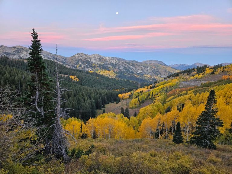
With that caveat out of the way, Pinecone is a beautiful 4-mile stretch of downhill singletrack that bobs and weaves through the upper sections of PCMR. Low berms keep the speed up and the flow high. "Occasionally the trail breaks out of fir and aspen forest for views of the surrounding canyons,” according to UtahMountainBiking.
Once at the Mid Mountain Trail, take a right and continue down and across for a couple of miles. Look for a left turn onto CMG.
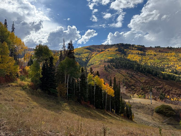
The upper section of CMG is technically a two-way trail, although most people descend it. The upper section is fast and wide-open, with a few rough rock sections to keep things interesting. None of the rock features are large or exceedingly technical, but they do provide a little entertainment and a welcome change from Park City's generally-smooth trail tread. As CMG winds around and down the mountain, beautiful views of Park City will open up below you.
The final section of CMG is downhill-only as it twists and turns through the dense forest near the base of the mountain. After swooping through a series of switchbacks, you’ll suddenly pop back out at the parking lot, asking yourself, “why does it have to be over already?!"
Sources:
https://mountaintrails.org/pinecone-trial-gem-of-the-wasatch/
https://www.utahmountainbiking.com/trails/pinecone.htm Written by Greg Heil
The Pinecone Trail was finished in 2012, and this addition to the Park City trail system was lauded as a “bar-setting, blow your mind, instant classic kind of trail,” according to [MountainTrails.org](https://mountaintrails.org/pinecone-trial-gem-of-the-wasatch/). While many people utilize this trail as a climbing route to reach the Wasatch Crest Trail, many riders logically opt to shuttle up to Guardsman Pass and ride Pinecone as a downhill shuttle run.
If you choose to ride Pinecone as a shuttle, be very mindful of uphill traffic. Remember that downhill riders always yield to uphill riders. That said, “when the trail is taken downhill, sightlines are longer than almost any other Park City trail,” according to [UtahMountainBiking.com](https://www.utahmountainbiking.com/trails/pinecone.htm).
With that caveat out of the way, Pinecone is a beautiful 4-mile stretch of downhill singletrack that bobs and weaves through the upper sections of PCMR. Low berms keep the speed up and the flow high. "Occasionally the trail breaks out of fir and aspen forest for views of the surrounding canyons,” according to UtahMountainBiking.
Once at the Mid Mountain Trail, take a right and continue down and across for a couple of miles. Look for a left turn onto CMG.
The upper section of CMG is technically a two-way trail, although most people descend it. The upper section is fast and wide-open, with a few rough rock sections to keep things interesting. None of the rock features are large or exceedingly technical, but they do provide a little entertainment and a welcome change from Park City's generally-smooth trail tread. As CMG winds around and down the mountain, beautiful views of Park City will open up below you.
The final section of CMG is downhill-only as it twists and turns through the dense forest near the base of the mountain. After swooping through a series of switchbacks, you’ll suddenly pop back out at the parking lot, asking yourself, “why does it have to be over already?!"
Sources:
https://mountaintrails.org/pinecone-trial-gem-of-the-wasatch/
https://www.utahmountainbiking.com/trails/pinecone.htm Written by Greg Heil