


+ 130
Mount Tammanay: Red Dot and Blue Dot Loop
远足路径
比较难
3.49英里
1,230英尺
A fairly steep and sometimes rough hike to stunning views above the Delaware River.
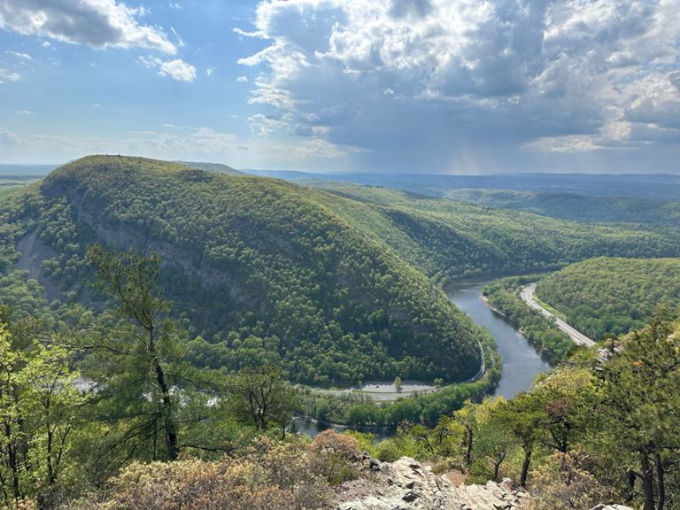
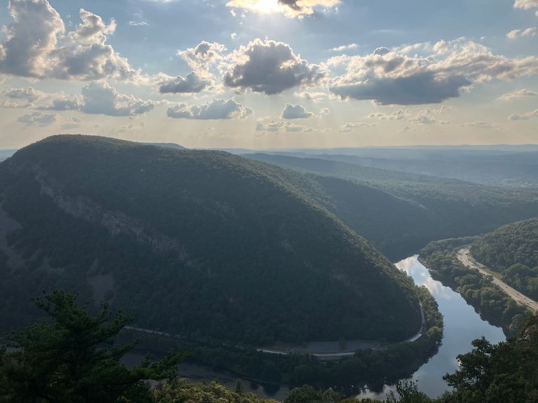
The Mount Tammany Red Dot hiking trail is a challenging and rewarding hike in New Jersey. It starts at the Dunnfield Creek Natural Area Trailhead, near Interstate 80. You will follow the red blazes up the steep and rocky slope of Mount Tammany. Some parts of the trail require scrambling and careful footing. The highlight of the hike is the summit of Mount Tammany, where you can enjoy a stunning view of the Delaware Water Gap and the surrounding mountains. You can also see some landmarks such as Mount Minsi, Sunfish Pond and Tocks Island Dam. This is a great spot to rest, eat and take photos. To complete the loop, you will descend along the Blue Dot Trail (Pahaquarry Trail), which is less steep and more gradual than the Red Dot Trail. You will pass by a swimming hole with some small waterfalls, where you can cool off if you want. You will then join the Appalachian Trail for a short stretch along Dunnfield Creek, before returning to the parking area. The trail is about 3.3 miles long and has an elevation gain of about 1,200 feet. It is rated as moderate to hard, depending on your fitness level and experience. It is best to hike this trail in spring, summer or fall, when the weather is mild and the foliage is colorful. In winter, the trail can be icy and slippery, so be prepared with proper gear and caution. This trail is very popular, so expect to see other hikers on weekends and holidays. It is also advisable to arrive early to secure a parking spot, as the lot fills up quickly. Dogs are welcome on this trail, but must be leashed at all times. The Mount Tammany Red Dot hiking trail is a great way to experience some of the best scenery that New Jersey has to offer. It is a hike that will challenge you physically and reward you visually. Sources: Mt. Tammany Trail (Red Dot) - National Park Service. https://www.nps.gov/dewa/planyourvisit/red-dot-trail.htm Hiking the Mt. Tammany Red Dot Trail in New Jersey. https://wildkidswander.com/mt-tammany-red-dot-trail/ Hike Mount Tammany's Red Dot and Blue Dot Loop, Columbia, New Jersey. https://www.theoutbound.com/new-jersey/hiking/hike-mount-tammany-s-red-dot-and-blue-dot-loop Conversation with Bing Chat Written by FATMAP Official
The Mount Tammany Red Dot hiking trail is a challenging and rewarding hike in New Jersey. It starts at the Dunnfield Creek Natural Area Trailhead, near Interstate 80. You will follow the red blazes up the steep and rocky slope of Mount Tammany. Some parts of the trail require scrambling and careful footing. The highlight of the hike is the summit of Mount Tammany, where you can enjoy a stunning view of the Delaware Water Gap and the surrounding mountains. You can also see some landmarks such as Mount Minsi, Sunfish Pond and Tocks Island Dam. This is a great spot to rest, eat and take photos. To complete the loop, you will descend along the Blue Dot Trail (Pahaquarry Trail), which is less steep and more gradual than the Red Dot Trail. You will pass by a swimming hole with some small waterfalls, where you can cool off if you want. You will then join the Appalachian Trail for a short stretch along Dunnfield Creek, before returning to the parking area. The trail is about 3.3 miles long and has an elevation gain of about 1,200 feet. It is rated as moderate to hard, depending on your fitness level and experience. It is best to hike this trail in spring, summer or fall, when the weather is mild and the foliage is colorful. In winter, the trail can be icy and slippery, so be prepared with proper gear and caution. This trail is very popular, so expect to see other hikers on weekends and holidays. It is also advisable to arrive early to secure a parking spot, as the lot fills up quickly. Dogs are welcome on this trail, but must be leashed at all times. The Mount Tammany Red Dot hiking trail is a great way to experience some of the best scenery that New Jersey has to offer. It is a hike that will challenge you physically and reward you visually. Sources: Mt. Tammany Trail (Red Dot) - National Park Service. https://www.nps.gov/dewa/planyourvisit/red-dot-trail.htm Hiking the Mt. Tammany Red Dot Trail in New Jersey. https://wildkidswander.com/mt-tammany-red-dot-trail/ Hike Mount Tammany's Red Dot and Blue Dot Loop, Columbia, New Jersey. https://www.theoutbound.com/new-jersey/hiking/hike-mount-tammany-s-red-dot-and-blue-dot-loop Conversation with Bing Chat Written by FATMAP Official
路线和海拔
路段
| 名字 | 距离 | 海拔高度差 | 平均坡度 |
|---|---|---|---|
| Red Dot Trail from Upper Lot - Rt 80 | 1.27英里 | 1,168英尺 | 17.3% |
| Red Dot Up | 1.19英里 | 988英尺 | 15.5% |
| Interstate 80 Climb | 1.31英里 | 1,217英尺 | 17.6% |
| Interstate 80 Climb | 0.23英里 | 203英尺 | 16.1% |
| Blue Dot Down | 2.08英里 | -1,109英尺 | -9.5% |
| Tammany Descent | 0.95英里 | -797英尺 | -15.8% |