


+ 106
Tour des Sommets de Lavande
Cycling Route
Details
84.7 km
1,337 m
Starting from Aurel Towards Ferrassières
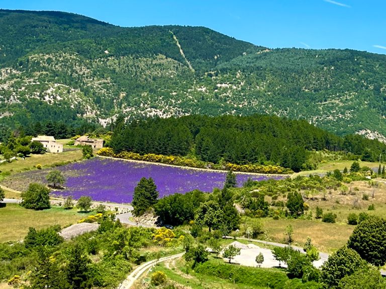
Our route begins in the charming village of Aurel, which dates back to the 11th century. Known for its stone houses and narrow streets, Aurel was once used by the Romans and played a crucial role as a defensive fortress during the Middle Ages. As you leave this peaceful village, you head towards Ferrassières with a gentle 1 km climb at a 5.2% gradient, all while surrounded by the stunning lavender fields and stone architecture of Aurel.
On the Road to Ferrassières
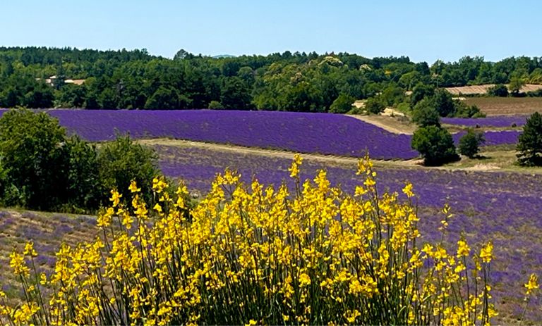
As you pedal towards Ferrassières, you’ll be greeted by the breathtaking sight of lavender fields. This village is considered the lavender capital of the Provence region. Ferrassières became an economic hub in the 19th century due to lavender cultivation, and the village still celebrates this legacy with traditional lavender festivals.
Collet de Lambert and Col de l’Homme Mort
The climb from Aurel continues for 0.72 km with a 6.6% gradient, followed by a 1.78 km stretch at a 4.7% gradient, bringing you to Collet de Lambert. Here, you’ll find yourself immersed in the natural beauty of Provence. From here, the route continues to Col de l’Homme Mort, a pass named after the challenges faced by caravans traveling through the region in the past. At this historical point, you’ll take on a rewarding climb of 6.48 km at a 4.9% gradient.
Col de Pigière and Col du Négron
After conquering Col de l’Homme Mort, a 20 km route with both gentle climbs and descents takes you to Col de Pigière and Col du Négron. Col du Négron, a historically significant pass used for centuries by traders and military forces, offers cyclists a thrilling challenge with its 7.9% gradient and spectacular views.
Descent to Sederon and the Road to Banon
As you descend from Négron towards Sederon at a 5.4% gradient, you approach the historic town of Sederon. With roots going back to the Gallo-Roman era, Sederon became a strategic defense point in the Middle Ages, known for its fortresses and medieval walls. From Sederon, you’ll continue to the village of Banon, home to renowned cheeses and traditional Provence architecture.
Banon and its Historical Heritage
Banon, a village steeped in history, has long been a cultural center. In the Middle Ages, Banon was a major trading hub, and today it’s famous for its Banon cheese. As you ride through the village’s ancient streets, you’ll see churches and stone buildings dating back to the 16th century. Here, you can enjoy a gentle descent and take a break while absorbing the village’s historical ambiance.
Return to Revest-du-Bion
In the final leg of the route, you make your way back towards Revest-du-Bion, a small village rich in history. Dating back to the 12th century, Revest-du-Bion is known for its medieval stone structures that still stand today. Once used as a fortress to protect the region during the Middle Ages, this village offers a perfect example of local Provençal culture and architecture.
This route offers not only the joy of cycling but also the chance to discover the rich history and cultural heritage of Provence. Pedaling through medieval villages, you’ll feel a deep connection to the past while enjoying the scenic beauty of this extraordinary region.
Our route begins in the charming village of Aurel, which dates back to the 11th century. Known for its stone houses and narrow streets, Aurel was once used by the Romans and played a crucial role as a defensive fortress during the Middle Ages. As you leave this peaceful village, you head towards Ferrassières with a gentle 1 km climb at a 5.2% gradient, all while surrounded by the stunning lavender fields and stone architecture of Aurel.
On the Road to Ferrassières
As you pedal towards Ferrassières, you’ll be greeted by the breathtaking sight of lavender fields. This village is considered the lavender capital of the Provence region. Ferrassières became an economic hub in the 19th century due to lavender cultivation, and the village still celebrates this legacy with traditional lavender festivals.
Collet de Lambert and Col de l’Homme Mort
The climb from Aurel continues for 0.72 km with a 6.6% gradient, followed by a 1.78 km stretch at a 4.7% gradient, bringing you to Collet de Lambert. Here, you’ll find yourself immersed in the natural beauty of Provence. From here, the route continues to Col de l’Homme Mort, a pass named after the challenges faced by caravans traveling through the region in the past. At this historical point, you’ll take on a rewarding climb of 6.48 km at a 4.9% gradient.
Col de Pigière and Col du Négron
After conquering Col de l’Homme Mort, a 20 km route with both gentle climbs and descents takes you to Col de Pigière and Col du Négron. Col du Négron, a historically significant pass used for centuries by traders and military forces, offers cyclists a thrilling challenge with its 7.9% gradient and spectacular views.
Descent to Sederon and the Road to Banon
As you descend from Négron towards Sederon at a 5.4% gradient, you approach the historic town of Sederon. With roots going back to the Gallo-Roman era, Sederon became a strategic defense point in the Middle Ages, known for its fortresses and medieval walls. From Sederon, you’ll continue to the village of Banon, home to renowned cheeses and traditional Provence architecture.
Banon and its Historical Heritage
Banon, a village steeped in history, has long been a cultural center. In the Middle Ages, Banon was a major trading hub, and today it’s famous for its Banon cheese. As you ride through the village’s ancient streets, you’ll see churches and stone buildings dating back to the 16th century. Here, you can enjoy a gentle descent and take a break while absorbing the village’s historical ambiance.
Return to Revest-du-Bion
In the final leg of the route, you make your way back towards Revest-du-Bion, a small village rich in history. Dating back to the 12th century, Revest-du-Bion is known for its medieval stone structures that still stand today. Once used as a fortress to protect the region during the Middle Ages, this village offers a perfect example of local Provençal culture and architecture.
This route offers not only the joy of cycling but also the chance to discover the rich history and cultural heritage of Provence. Pedaling through medieval villages, you’ll feel a deep connection to the past while enjoying the scenic beauty of this extraordinary region.