


+ 75
M2M Day 1
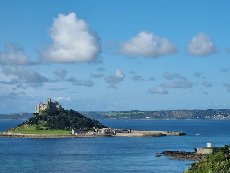
Rota de ciclismo
Detalhes
75,89 milhas
6 398 pés
Marazion to Plymouth
Criado por
Andy Pittey

Rota e elevação
Segmentos
| Nome | Distância | Dif. Elevação | Inclinação Média |
|---|---|---|---|
| Though and out of Marazion | 2,65 milhas | 249 pés | 1,7% |
| Top of Marazion | 0,40 milhas | 66 pés | 3,1% |
| through Goldsithney | 0,96 milhas | 69 pés | 0,1% |
| St Hilary climb | 0,24 milhas | 69 pés | 5,1% |
| Tregembo Hill | 0,62 milhas | 161 pés | 4,5% |
| Tregembo Hill to Leedstown | 2,82 milhas | 240 pés | 1,6% |
| Townsend to Leedstown | 1,26 milhas | 105 pés | 0,8% |
| leedstown to praze | 2,13 milhas | 59 pés | 0,1% |
| Just out of Praze-an- Beeble up to junction | 1,47 milhas | 276 pés | 3,5% |
| Black Rock (long) | 2,94 milhas | 436 pés | 2,8% |
| Black Rock West | 1,17 milhas | 266 pés | 4,2% |
| 400mtr hill rep session | 0,26 milhas | 98 pés | 7,1% |
| 500mtr hill rep session | 0,50 milhas | 118 pés | 4,4% |
| Blackrock corner to New Road | 1,48 milhas | 102 pés | 1,3% |
| Cargenwyn Rise | 0,31 milhas | 52 pés | 2,9% |
| Sprint for Four Lanes turn | 0,59 milhas | -89 pés | -2,7% |
| How fast can you go | 0,28 milhas | -79 pés | -5,2% |
| Four Lanes sprint | 0,47 milhas | -13 pés | 0,0% |
| The Duck( Sportsmans) to Victoria | 0,23 milhas | 7 pés | 0,6% |
| Where exactly ? | 0,43 milhas | 33 pés | 1,2% |
| Frogpool Flyer | 1,07 milhas | -105 pés | -1,3% |
| A393 - Reeves' Corner | 1,65 milhas | -105 pés | -1,2% |
| give em hang | 0,24 milhas | -20 pés | -1,6% |
| Greensplatt Sprint | 0,31 milhas | 43 pés | 2,5% |
| Bissoe Climb, Cornwall | 0,88 milhas | 285 pés | 6,1% |
| 40 Sign to the Dotted Lign | 0,43 milhas | 177 pés | 7,8% |
| Wheal Jane to Junction | 0,56 milhas | 102 pés | 3,5% |
| Hoon outta Baldhu | 0,40 milhas | -75 pés | -3,4% |
| Pound Lane Leg Warmer | 0,44 milhas | 39 pés | 1,4% |
| Zoooooooom | 0,36 milhas | -131 pés | -6,8% |
| Ride | 0,32 milhas | 39 pés | 2,3% |
| bridge to bridge | 0,50 milhas | 23 pés | 0,4% |
| Morlaix Sprint | 0,18 milhas | -7 pés | -0,5% |
| The HIll | 0,44 milhas | 174 pés | 7,5% |
| Through Tresillian | 1,05 milhas | -30 pés | -0,1% |
| Business Park to Truck Hill | 0,77 milhas | 33 pés | 0,5% |
| Truck Hill | 0,53 milhas | 108 pés | 3,8% |
| Leave Maccies in a hurry | 0,20 milhas | 20 pés | 1,8% |
| St Austell Bypass Eastbound | 0,95 milhas | 95 pés | 1,9% |
| St Austell bypass roundabout run east | 0,74 milhas | 69 pés | 1,6% |
| Asda to lights blast | 0,16 milhas | 39 pés | 4,6% |
| SAW - SKYRIDE - GOING FOR GREEN | 1,34 milhas | -30 pés | -0,4% |
| par up | 0,43 milhas | 33 pés | 0,9% |
| Where's the Camp Nou? | 0,41 milhas | 69 pés | 3,1% |
| oaklands park to Bridge | 1,88 milhas | -377 pés | -3,7% |
| St Martins Climb | 0,82 milhas | 230 pés | 4,8% |
| 2k chase | 1,43 milhas | -62 pés | -0,2% |
| Sprint from the ferry before the lights go out | 0,17 milhas | 69 pés | 7,3% |
| Treacle: Ferry Rd tls - Fore St tls | 0,32 milhas | -39 pés | -1,0% |
| Stonehouse Bridge to Plym | 0,11 milhas | -20 pés | -3,2% |