


+ 12
YGR Gravel 4: *Pain in the ass pass* (51 miles)
Ruta ciclista
Detalles
51,45 mi
1.968 ft
The couple of miles along highway 287 have lots and fast traffic, but there is
a good shoulder. Turn left onto Owl Canyon Road to get back less traveled
routes, but expect the occasional truck to come by as they take that route to
or from the interstate without having to go through town.
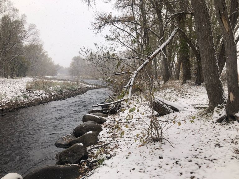
I don’t know whether Pain in the Ass Pass is an actual name, but I was
introduced to this route by former pro rider Alex Hagman, and who am I to
argue with him about the name. Regardless, do this route in the spring when
everything is green and Red Mountain Open Space is, well, red. The contrast of
these colors as you climb going west over the pass on LCR 80, with the Park
Creek Reservoir below you, is fantastic. As you start heading back, stop at
the store in Livermore and have a cinnamon roll — some people call this route
the “Cinnamon Roller” for this reason. This is also the only place to get
water. From Livermore, you're on paved roads all the way home, and most of it
is downhill, so you'll be home relatively quickly.
a good shoulder. Turn left onto Owl Canyon Road to get back less traveled
routes, but expect the occasional truck to come by as they take that route to
or from the interstate without having to go through town.
I don’t know whether Pain in the Ass Pass is an actual name, but I was
introduced to this route by former pro rider Alex Hagman, and who am I to
argue with him about the name. Regardless, do this route in the spring when
everything is green and Red Mountain Open Space is, well, red. The contrast of
these colors as you climb going west over the pass on LCR 80, with the Park
Creek Reservoir below you, is fantastic. As you start heading back, stop at
the store in Livermore and have a cinnamon roll — some people call this route
the “Cinnamon Roller” for this reason. This is also the only place to get
water. From Livermore, you're on paved roads all the way home, and most of it
is downhill, so you'll be home relatively quickly.
Creada por
Dan Porter- YGR

Ruta y desnivel
Segmentos
| Nombre | Distancia | Diferencia de desnivel | Pendiente media |
|---|---|---|---|
| Poudre - top of Shields | 3,08 mi | 131 ft | 0,8 % |
| 287 to douglous | 1,05 mi | 52 ft | 0,6 % |
| lake front tt | 2,66 mi | 118 ft | 0,3 % |
| North Shields Hill | 1,01 mi | 128 ft | 2,4 % |
| Kluver Kicker Northbound | 0,33 mi | 66 ft | 3,8 % |
| just keep swimming | 0,77 mi | -69 ft | -1,7 % |
| No time for recovery | 1,18 mi | -52 ft | -0,7 % |
| cement plant road to CR 64 on Taft | 3,88 mi | 164 ft | 0,8 % |
| w co rd 64 eastward | 0,94 mi | -33 ft | -0,5 % |
| n co rd 17 gravelo climb (buckeye) | 7,91 mi | 427 ft | 1,0 % |
| no butts about it | 1,67 mi | 72 ft | 0,7 % |
| W Co Rd 80 (E to W) | 9,22 mi | 427 ft | 0,6 % |
| Buckeye Roubaix | 8,16 mi | 436 ft | 0,5 % |
| Park Creek Reservoir | 1,13 mi | 299 ft | 5,0 % |
| BTBGF Niner Park Creek Rez segment | 1,22 mi | 295 ft | 4,5 % |
| red space kicker | 0,25 mi | 59 ft | 4,0 % |
| CR 72 Dirt | 2,96 mi | -299 ft | -1,9 % |
| Owl Canyon 287 to Roundabout | 4,85 mi | -348 ft | -1,4 % |
| Go Spurs! | 1,81 mi | -92 ft | -0,7 % |
| Co Rd 72 Punch | 0,27 mi | 46 ft | 2,5 % |
| THTT_justSouth | 5,77 mi | -236 ft | -0,7 % |
| Brokebarn Mountain | 0,63 mi | 36 ft | 0,5 % |
| Feelin' Groovy | 1,09 mi | 30 ft | 0,3 % |
| Flat out to the turn | 1,62 mi | 56 ft | 0,1 % |
| Kluver Res Kicker | 0,32 mi | 49 ft | 2,3 % |
| Kluver Climb road to top | 0,21 mi | 36 ft | 3,3 % |
| Top of Shields to the river | 3,02 mi | -135 ft | -0,8 % |
| Top of Shields to 287 | 1,45 mi | -118 ft | -1,4 % |
| Sheilds Street Flyer | 0,91 mi | -52 ft | -0,7 % |
| 287 to the river | 1,51 mi | -39 ft | -0,4 % |