Strava
Handy
Features
Mitglied werden
Karten
Geschichten
Registrieren
Anmelden
+ 35
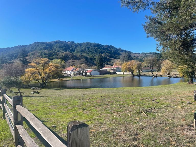
Petaluma coastal route 2
Radroute
Speichern
Teilen
Einbetten
URL kopieren
TCX exportieren
GPX exportieren
Drucken
Details
50,14 mi
2.945 ft
Opposite direction, hopefully the wind guides me home
Erstellt von
Fernando Arellano
27. August 2015
·
Öffentlich
Route und Höhe
Segmente
Name
Distanz
Höhenunterschied
Steigung
D St ascend
1,44 mi
236 ft
3,0 %
D St to top of Red Hill
6,15 mi
594 ft
1,8 %
sunnyslope to white barn
4,35 mi
236 ft
0,5 %
First D street climb
1,29 mi
236 ft
3,5 %
D st south from Windsor Dr to San Antonio
3,05 mi
-174 ft
-0,0 %
Petaluma Rd San Antonio to Hicks Valley
3,83 mi
531 ft
1,3 %
Red Hill Rd Climb from Petaluma
1,32 mi
427 ft
6,0 %
Red Hill Descent South to Hicks Valley Rd.
1,06 mi
-220 ft
-3,7 %
Hicks Road to Nicasio Valley Road
4,11 mi
-358 ft
-1,0 %
PtReyesPetaluma: NovatoBlvd to Plunge
2,32 mi
161 ft
1,2 %
Hicks Mountain Run
3,75 mi
-364 ft
-1,0 %
Robin's run
2,07 mi
125 ft
1,2 %
Nicasio Res/Flag Hill descent
1,78 mi
-371 ft
-3,4 %
Descent to Nicasio Reservoir
1,63 mi
-381 ft
-4,0 %
Droppin' in to West Marin
4,44 mi
-489 ft
-2,1 %
Point Reyes-Petaluma Descent
0,89 mi
-282 ft
-6,0 %
Nicasio to Tomales
22,22 mi
-203 ft
-0,1 %
Pt Reyes-Pet., fast section
3,85 mi
-200 ft
-0,6 %
Nicasio Dam to Platform Bridge Rd
0,77 mi
-125 ft
-3,1 %
Platform Bridge to Hwy 1 Stop Sign
3,03 mi
69 ft
0,0 %
Platform Bridge to Pt Reyes
1,95 mi
-62 ft
-0,0 %
Point Reyes Station Roaster's Kicker Sprint
0,15 mi
49 ft
6,1 %
Point Reyes Station Kicker Sprint II
0,09 mi
52 ft
10,9 %
Rt 1, Pt Reyes Station to Tony's Seafood, Marshall
7,84 mi
-138 ft
-0,2 %
Pt Reyes to Marshal
9,32 mi
-128 ft
-0,1 %
Pt. Reyes to Tomales
15,28 mi
-180 ft
-0,1 %
Hwy1 Pt Reyes to Marshall (Cypress to Store)
7,32 mi
-138 ft
-0,2 %
14700 to Tomales Oyster Farm
1,86 mi
26 ft
0,0 %
14700 Hwy 1 to Nicks Cove
9,14 mi
-105 ft
-0,0 %
Milerton to Hog Island
5,12 mi
-98 ft
-0,1 %
Marshall to windsurfing parking lot
1,88 mi
128 ft
0,4 %
Highway 1: Marshall to Tomales
6,88 mi
131 ft
0,1 %
flats into tomales
3,51 mi
112 ft
0,0 %
windtunnel take 2
2,10 mi
-108 ft
-0,9 %
Flats from scenic overlook to Tomales Petaluma
2,31 mi
-82 ft
-0,4 %
Jammin"
1,17 mi
-26 ft
-0,1 %
Tomales to Chileno going east
5,12 mi
171 ft
0,1 %
Tomales Rd (complete)
6,75 mi
135 ft
0,1 %
tomales road
3,14 mi
-85 ft
-0,2 %
Tail Winds
1,60 mi
39 ft
0,4 %
Spring Hill - Church to Purvine
2,07 mi
184 ft
1,2 %
Springhill (Full)
7,06 mi
417 ft
0,2 %
Spring Hill Road Climb
5,04 mi
371 ft
1,3 %
Stemer to Purvine
0,65 mi
144 ft
4,0 %
Spring Hill East Purvine to Chileno
5,07 mi
-266 ft
-0,1 %
Spring Hill East Climb
0,42 mi
102 ft
4,5 %
Spring Hill Final Climb
1,02 mi
236 ft
4,4 %
Spring Hill Descent
1,38 mi
-331 ft
-4,5 %
Windsor Drive Petaluma Eastbound
1,30 mi
-141 ft
-0,9 %