
Mês passado

Mês passado

Mês passado


+ 194
The Cumbrian Cracker
Rota de ciclismo
Detalhes
56,87 milhas
4 694 pés
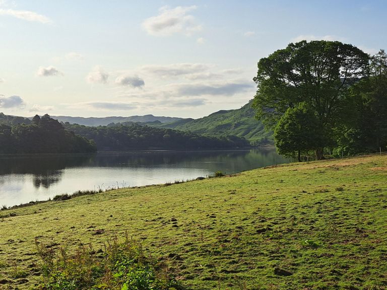
The Cumbrian Cracker takes place from Grasmere Village Hall. The route is just short of 60 miles and heads South along the shores of Coniston to the feed stop at Cartmel Scout Hut. Following the feed stop the Northern leg then weaves it's way through fantastic cycling lanes, returning via Grizedale forest, Hawkshead and Ambleside.
You will see some fantastic views as you ride alongside Coniston Lake.
The route is undulating but does not climb any of the major passes, the roads in South Lakeland are some of the best you will ever ride and well worth the trip!
Hot food is available for everyone at the finish.
You will see some fantastic views as you ride alongside Coniston Lake.
The route is undulating but does not climb any of the major passes, the roads in South Lakeland are some of the best you will ever ride and well worth the trip!
Hot food is available for everyone at the finish.
Criado por
Chris S

Rota e elevação
Segmentos
| Nome | Distância | Dif. Elevação | Inclinação Média |
|---|---|---|---|
| Cumbrian Cracker sportive | 56,49 milhas | 682 pés | 0,0% |
| Red Bank Climb | 0,46 milhas | 56 pés | 1,6% |
| Grasmere to top of Redbank | 1,65 milhas | 374 pés | 4,0% |
| grassmere to backbarrow cumbrian cracker | 21,53 milhas | -548 pés | -0,2% |
| Red Bank long | 0,73 milhas | 276 pés | 7,1% |
| Red bank 25% | 0,27 milhas | 210 pés | 14,6% |
| Red Bank Climb | 0,52 milhas | 262 pés | 9,5% |
| The chase | 2,52 milhas | -364 pés | -2,0% |
| from yha to elterwater | 0,75 milhas | -348 pés | -8,5% |
| Elterwater to Windy Ridge | 1,28 milhas | -82 pés | -0,2% |
| Side Gates climb | 0,29 milhas | 95 pés | 5,6% |
| Oxen Fell A593 | 0,82 milhas | 269 pés | 6,2% |
| hodge close to whins wood | 1,62 milhas | -125 pés | -1,3% |
| Coniston to Allithwaite | 19,90 milhas | -299 pés | -0,1% |
| brantwood climb | 1,30 milhas | 167 pés | 1,1% |
| Townson Ground | 0,47 milhas | 144 pés | 5,8% |
| The Blue Bird Sprint (LFCC) | 7,26 milhas | -197 pés | -0,3% |
| High Nibthwaite to Cartmel Cumbria Cracker | 15,94 milhas | -240 pés | -0,1% |
| End of the Lake to the Bridge | 1,78 milhas | -72 pés | -0,5% |
| Lowick bridge to Sayles farm | 0,56 milhas | 82 pés | 2,8% |
| Lowick Bridge To Spark Bridge | 1,38 milhas | -125 pés | -0,7% |
| Crossroads after Spark Bridge to Bouth | 1,51 milhas | -118 pés | -0,9% |
| Bouth to A590 | 1,27 milhas | -98 pés | -0,7% |
| The Causeway | 0,46 milhas | -26 pés | -0,3% |
| Haulin' to Holker | 4,25 milhas | 112 pés | 0,3% |
| The Mosses Southbound | 3,73 milhas | 56 pés | 0,0% |
| Punch up to Holker | 0,19 milhas | 52 pés | 5,2% |
| Allithwaite climb | 0,48 milhas | 167 pés | 6,5% |
| Cartmel to Field Broughton | 1,67 milhas | 184 pés | 1,8% |
| Cumbrian Cracker 2nd half | 25,37 milhas | 673 pés | 0,1% |
| Cartmel to Stribers' turn | 2,29 milhas | 354 pés | 2,9% |
| Cracker Cafe Legs Punisher (Epic Events) | 3,28 milhas | 476 pés | 2,7% |
| Tarn Haw Kick | 0,30 milhas | 75 pés | 4,5% |
| Low Wood Road Decent | 1,22 milhas | -541 pés | -8,3% |
| Bridge to Road through Haverthwaite | 0,64 milhas | 89 pés | 1,6% |
| Causeway to Rusland Cross | 2,98 milhas | 66 pés | 0,1% |
| Chain Fail Hill | 0,25 milhas | 102 pés | 7,4% |
| Satterthwaite to Visitor Centre | 0,63 milhas | 20 pés | 0,0% |
| Grizedale → Moor Top | 1,49 milhas | 325 pés | 4,1% |
| Elder Ghyll Climb | 1,00 milhas | 266 pés | 5,0% |
| Moor Top to Hawkshead | 1,09 milhas | -413 pés | -7,1% |
| Sprint for Cake | 0,21 milhas | -26 pés | -0,5% |
| Hawkshead-Ambleside (again but proper) | 4,59 milhas | -246 pés | -0,4% |
| Outgate Climb | 0,59 milhas | 105 pés | 3,3% |
| hawkshead to outgate climb | 0,62 milhas | 125 pés | 3,6% |
| Wray to Clappersgate | 1,49 milhas | -72 pés | -0,4% |
| New track North to Clappersgate | 0,54 milhas | -72 pés | -0,7% |
| Clappersgate to the Bridge | 0,40 milhas | -30 pés | -1,1% |
| Under Loughrigg | 1,58 milhas | -66 pés | -0,5% |
| FWC sprint | 1,21 milhas | 23 pés | 0,2% |