route-highlight
7 derniers jours
route-highlight
30 derniers jours
route-highlight
30 derniers jours
route-highlight
30 derniers jours
route-highlight
30 derniers jours
route-highlight
+ 179

Woodside to Coast Long Loop

Itinéraire de sortie à vélo

Détails
57,15 mi
6 702 pi
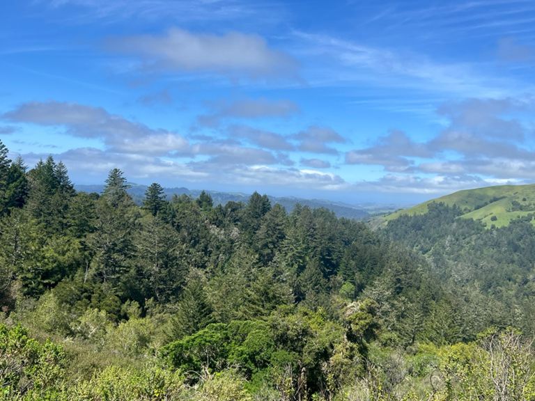
Woodside to Pescadero PAVED ROADS WITH MODERATE CAR TRAFFIC Total Distance: 57.1 miles Elevation Gain: 5800 feet Riding Time: 5-7 hours Summary: For an epic cycling adventure in the San Francisco Bay Area this demanding loop cannot be beat. A lot of hill climbing and a lot of scenery make up this all-day ride from Woodside to the coast. With 5800 fee of elevation gain it is not for the faint of heart. But there are enough serious cyclists living on the Peninsula that every weekend hundreds of them take this epic ride. The rides first 6.6 miles mimic the shorter Woodside to Skyline Short Loop. But this time you head south on Skyline passing Windy Hill and Russian Ridge Open Space Preserves while gaining another 500 feet then turn west on Alpine Road. Descend 2000 feet in the next seven miles. Most of it is open grasslands but you also pass through a stretch of old-growth redwoods called the Heritage Grove in Alpine Roads last two miles. Lock up your bike a take a short walk through these magnificent trees. With a left turn on Pescadero Rd you will climb again over a steep grade for almost two miles. But then you drop again this time all the way to sea level in the town of Pescadero. After a food and rest break in this small village Stage Rd and Hwy 1 take you over comparitively easy terrain (two 300-foot climbs) to Tunitas Creek Road where you begin you last major climb of the day. This nine-miler is one of the favorite training rides of cyclists on the coast. The majority of it is in shady redwoods the climb holds an average 6 percent grade (total 2000-foot gain) and cars are a rarity. The last six miles from Skyline Boulevard are all downhill back to your car.
Créée par
Jonathan K

Itinéraire et dénivelé

Segments

NomDistanceDéniveléPente moy.
Whiskey Hill Road, Woodside to Sand Hill1,24 mi-108 pi-1,5 %
WS to top of OLH4,02 mi617 pi2,5 %
White Mailbox Sprint0,57 mi-16 pi-0,2 %
Sand Hill - Manzanita to peak0,19 mi79 pi7,8 %
Sand Hill Stinger0,38 mi102 pi4,9 %
Old La Honda - Mile 10,99 mi371 pi7,0 %
Old La Honda - LowKey3,06 mi1 250 pi7,7 %
Old La Honda - Mile 20,99 mi397 pi7,5 %
Old La Honda - Mile 30,99 mi390 pi7,4 %
Upenough to Mailboxes0,81 mi318 pi7,4 %
OLH Mile 3 to End0,25 mi102 pi7,5 %
Skyline - Old La Honda to Page Mill5,79 mi709 pi1,9 %
Razorback Ridge Trail Climb0,48 mi125 pi4,8 %
Rapley to Crazy Petes (on Hwy 35)0,91 mi213 pi4,4 %
Alpine Rd. bump0,88 mi131 pi2,8 %
West Alpine descent4,81 mi-2 500 pi-0,0 %
Pescadero Cr rd (from Alpine rd)1,59 mi574 pi6,8 %
07/04/10 Menlo Park, CA0,82 mi289 pi6,3 %
Haskins W Descent to Camp Loma Mar2,00 mi-741 pi-7,0 %
Top of Haskins to Pescadero7,52 mi-236 pi-0,6 %
Pescadero Creek Rd. Sprint (Cloverdale rd to stage rd)0,52 mi-39 pi-1,3 %
Stage Road Descent #11,05 mi-282 pi-4,9 %
Stage Rd [NB] - Final Hill2,61 mi-397 pi-0,8 %
Stage Rd Climb [NB] - from Pomponio Cr Rd0,79 mi289 pi6,9 %
Stage Rd.1,01 mi374 pi7,0 %
Route 1 Downhill Sprint1,53 mi-446 pi-4,4 %
Hwy 1 Downhill to Tunitas Creek0,81 mi-266 pi-6,2 %
Tunitas Creek9,13 mi1 929 pi3,9 %
Tunitas Creek - Hwy1 to Lobitos Creek Rd3,64 mi394 pi1,8 %
Tunitas Creek Rd -- Highway 1 to the Bike Hut0,90 mi85 pi0,9 %
Tunitas Creek - HWY 1 to Lobitos Creek Cutoff2,01 mi174 pi0,8 %
Tunitas + Kings: HWY 1 to Stop Sign at Base13,52 mi1 955 pi0,5 %
Tunitas Creek - Bike Hut Squatter!0,84 mi62 pi1,4 %
Tunitas - Cutoff to Lobitos Proper1,61 mi302 pi3,4 %
Tunitas Creek Lower Climb (redwood to Mitchell Crk)1,30 mi420 pi6,1 %
Tunitas Creek - Lobitos Creek to Skyline5,90 mi1 617 pi5,4 %
Tunitas—Lobitos Ck to Grassy Knoll2,72 mi1 135 pi7,9 %
Tunitas Creek - Steep part to top4,75 mi1 394 pi5,6 %
Tunitas Creek - Steep(s)1,20 mi600 pi9,4 %
Tunitas climb - in shadow of Bald Knob0,61 mi282 pi8,6 %
Top Part of Tunitas2,74 mi476 pi3,4 %
Tunitas Creek Climb - as it flattens out0,42 mi167 pi5,9 %
Tunitas, Star Hill to Skyline1,18 mi164 pi2,6 %
Kings Mtn Rd descent (be careful)4,07 mi-1 529 pi-7,1 %
Kings Mtn Descent - Huddart to intersection1,27 mi-453 pi-6,7 %
Tripp to Manuella Sprint0,40 mi-20 pi-0,6 %
PV: Kings Tripp to Woodside0,62 mi-23 pi-0,7 %
Kings-Roberts Sprint0,71 mi-30 pi-0,6 %
PV: 84 Kings to Woodside0,57 mi-20 pi-0,7 %
Woodside Rd Sprint: Roberts Market to Whisky Hill0,20 mi36 pi3,3 %